|
SACRED GEOMETRY ON THE ISLAND OF BALI
Ancient Ley Lines in Candidasar
Extracts from an article published in Journal of the Royal Asiatic Society, ii 1973, 141-55.
In the eastern provinces of Bali the road to Karangasem passes a small exquisite lake surrounded by palm trees. Behind the lake rise a number of dramatic hills framing it towards the north, while beyond it the Indian Ocean sweeps to the horizon. In the distance through the blue haze lie the "islands of exile", the biggest of which is called Nusa Penida, while closer inshore a group of small rocks juts vertically out of the sea. The lake is sacred. The two temples to Shiva and Hariti look down from the hill.
It is the holy precinct of Tjandidasa that I first visited in 1971.
Every side of the lake and every sacred building is aligned geometrically. It is a remarkable example of conscious landscaping designed to integrate the work of men - in the lake and the temples, with the earthly realities that form their foundation.
When walking round the lake I stopped at the shrine on the northern side (S on the map) built in the form of a throne where the god is wont to sit. It was draped in the black-and-white-checked cloth that guards against the malevolence of evil spirits. With its back to the road the shrine looks out to sea, and when I stood beside it and looked towards the similar twin shrines which flank the outlet from the lake (T) I was surprised to see that I was standing on an axis which continued to one of the nearby islands. This could hardly be denied.
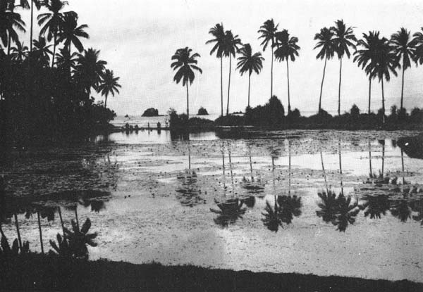
PHOTO: Lake and islands taken from the Hariti temple.
Climbing the wall behind the shrine, I then walked back along the road until I sighted the next island through the outlet T. I found I was-standing near the massive gates (M) of the temple of Hariti, and when I walked through the gate, there was a second axis from M via T to a second small island locally called Gili Kambing. It was almost too good to be true.
At the edge of the lake, where the southern edge bent sharply inwards at D, I could see that another axis led from the road up to the higher more important temple to the Great God himself, Shiva. None of these axes followed the cardinal points.
The Shiva temple - a simple enclosure with a lingam of Shiva - was not oriented to the sun either, for it faced more or less to the south-west-a direction the orthodox Balinese consider dangerous and inauspicious. But from the pinnacle of the canopy I saw in line with it the topmost peak of the nearby hills crowned with another temple, the Puru Gumang.
The second drawing shows that every element in the complex had been carefully oriented to each other and to the landscape. This system is known in Europe as Lay lines. Books have been written on this by Watkins and Michel.
This integrated situation is not found in the hinterland of Bali, where houses and temples are generally oriented to the sun, particularly around Ubud. These look to the mother temple at Besakih below the huge volcanic mountain Gunung Agung, considering that this is their north, though it is to the north-cast. This emphasis on the cardinal points, like the occupation of central Bali, may have been the work of the Majapahit Hindu invaders of the fifteenth century - a recent innovation that overlay the more ancient topographical tradition. The older tradition is affirmed by the fact that none of the axes at Tjandidasa are cardinally oriented, but are all topographically oriented.
The pre-Majapahit people - the Bali-Aga - used ley lines, the invaders oriented to the 'north'. Two cultures, two different ways to acknowledge in their sacred sites the earth that sustained them.
This ley line structure applied, as far as I could see in '71 and from the ordnance maps, to the whole southern coast. The axis through the Shiva temple was aligned on Pura Gumang to the north-east, and in the other direction a hill rising sharply to a peak, quite treeless except for a pronounced crown of tall trees on the summit with the temple of Bukit Glogor. In front of this hill are two lower hills separated by a pass, while a stream cuts an almost straight path from the pass to the sea. Stream, pass, and peak are in line with these three temples.
It may be that these temples are part of a gigantic topographical arrangement of trigonometrical points from which many other religious sites on the island might have been located and oriented. I suspect that the web of geometry laid over the small area of Tjandidasa is only a microcosm of what may be found through the rest of Bali.
For Hilary's forthcoming book on Bali click here.
|